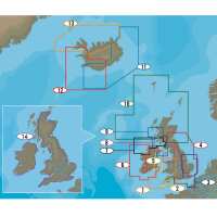
C-Map 4D MAX offers the moat advanced navigational features for your cruising, fishing and sailing needs. 4D Max features Guardian alarm for obstacle avoidance, Ocean currents, Aerial phots, Land elevations, Detailed roads, Depth areas and contours, Spot soundings, Navaids, Light sectors, Wrecks and obstructions, Anchorage areas, Small craft facilities and more. 4D MAX+ offers all the features of 4DMax with the addition of High resolution satellite imagery, 3D views, Easy routing and Raster charts. 4D MAX is the latest evolution of electronic charting technology, combining award-winning vector chart data with exclusive Dynamic Raster Charts and the ability to view charts in 2D or amazing 3D presentation with high-resolution satellite imagery. Packed with innovative features designed to enhance every cruising, fishing or sailing experience. Compatible with top chart plotter manufacturers including, Furuno, Humminbird, Raymarine and Standard Horizon Local and Wide coverage available worldwide, and at a budget that suits your boating needs Ability to add future Value Added Data segments and features 1. Liverpool to Weymouth EW-D321 2. Lizard Point to Littlehampton EW-D319 3. England South East Coasts EW-D040 4. Montrose to Ramsgate EW-D326 5. Strangford Lough to Saltee EW-D028 6. Ireland West and South West Coasts EW-D333 7. Donegal Bay to Rathlin Island EW-D330 8. Irish Sea and North Channel EW-D332 9. Kyle of Lochalsh to Isle of Man EW-D323 10. Western Isle to Fair Isle EW-D324 11. East and South EN-D411 12. South, Capital, West EW-D412 13. Westfjord, North East and South West EN-D410 14. UK and Ireland Inland Waters EW-D334 FULL FEATURED VECTOR CHARTS Provides a wealth of chart detail with the versatility to customize data layers and how they are viewed. DYNAMIC RASTER Traditional “paper chart” look with unique ability to access information on buoys, lights and other details. 3D VIEW Stunning three-dimensional views of land elevation and bottom contours bring the world around (and under) your boat to life. HIGH RESOLUTION BATHY The highest available detail of underwater pinnacles, ledges and canyons that are magnets for offshore and coastal gamefish. EASY ROUTING Automatically plots the shortest, safest route based on detailed chart data and user vessel information. * Easy Routing is not available in the US Compatiblilty a Series c Series eS Series gS Series Dragonfly, Dragonfly Pro (4D MAX only) Axiom, Axiom Pro (4D Max+) Element (4D Max+) GP-1670, GP-1670F (4D Max+) GP-1870, GP-1870F (4D Max+) GP-1871F, GP-1971F (4D Max+) CPN700I CPN1010I Supplied on Micro SD Card with Full SD adapter - Please specify the make & model of your plotter when ordering so we can supply the correct format. PLEASE NOTE: Due to Programming - Electronic Charts are not available on Next Day Shipping Services
About Force 4 Chandlery:
Supplying sailing equipment to sailors & boaters for 40+ years, offering quality & value for money.
Visit Product Page