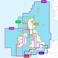
Plot your paradise -; with the best, most up-to-date Garmin Navionics+™ marine cartography on your compatible Garmin chartplotter. For offshore or inland waters, get detail-rich integrated mapping, shaded depth contours, advanced Auto Guidance+™ technology1 and access to daily updates via the ActiveCaptain® app. Combining the best features of Garmin and Navionics® automatic routing solutions, Auto Guidance+ gives you a suggested dock-to-dock path to follow through channels, inlets, marina entrances and more. UK Regular size areas EU003R - Great Britain, Northeast Coast EU004R - Irish Sea EU006R - Scotland, West Coast EU072R - UK & Ireland Inland, Lakes & Rivers EU074R - England, South Coast EU075R - Ireland, West Coast ALL-IN-ONE MAP SOLUTION FOR GARMIN CHARTPLOTTERS Access detail-rich mapping of coastal features, lakes, rivers and more. Integrated Garmin and Navionics content offers coverage for boaters worldwide. DAILY CHART UPDATES Charts are constantly being enhanced with new and amended content -; as many as 5,000 updates are made every day. The one-year included subscription gives you access to daily chart updates via the ActiveCaptain smart device app. AUTO GUIDANCE+ TECHNOLOGY Combining the best of Garmin and Navionics automatic routing features, built-in Auto Guidance+ technology1 gives you a suggested dock-to-dock path to follow through channels, inlets, marina entrances and more. DEPTH RANGE SHADING High-resolution depth range shading lets you select up to 10 colour-shaded options and view your designated target depths at a glance. UP TO 0.5 M CONTOURS For improved fishing and navigation, up to 0.5 m contours provide a clear depiction of bottom structure for improved fishing charts and enhanced detail in swamps, canals, harbours, marinas and more. SHALLOW WATER SHADING To give a clear picture of shallow waters to avoid, this feature allows for shading at a user-defined depth. ACTIVECAPTAIN COMMUNITY Community-sourced content provides useful POIs, such as marinas, anchorages, hazards, businesses and more. Get recommendations from boaters with first hand experience of the local environment. Garmin Navionics+ vs Garmin Navionics Vision+ Comparison 1 Auto Guidance+ is for planning purposes only and does not replace safe navigation operations. Supplied on Micro SD Card with Full SD adapter - Please specify the make & model of your plotter when ordering so we can supply the correct format. PLEASE NOTE: Some Electronic Charts are not available on Next Day Shipping Services as they are directly dispatched from the supplier.
About Force 4 Chandlery:
Supplying sailing equipment to sailors & boaters for 40+ years, offering quality & value for money.
Visit Product Page