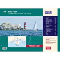
Imray Solent Chart Atlas Selsey Bill and the Isle of Wight to Christchurch The Imray 2000 chart series is a range of handy-sized charts ideal for use on small chart tables and in open cockpits. Published to cover popular cruising areas, the charts are at convenient scales and are clearly edited. Printed in colour on water-resistant paper, they are based on up-to-date official hydrographic surveys with Imrays distinctive colour scheme, coloured light sectors and fine overprinted latitude and longitude grids to make plotting easier. • Small format A2 size - 590mm x 420mm • Supplied with a plastic wallet • Water-resistant Pretex paper • MCA recognised for use on coded vessels and fishing vessels under 24m in length • WGS 84 Datum - datum & projection detailed for GPS navigation systems • Corrected to date of issue with free updating service thereafter The pack of charts for The Solent includes; 2200.1 Isle of Wight 1: 100 000 WGS 84 2200.2 Christchurch to the Solent 1: 60 000 WGS 84 Plans Lymington River, Christchurch 2200.3 Eastern Approaches to the Solent 1: 60 000 WGS 84 2200.4 Chichester & Langstone Harbours 1: 35 000 WGS 84 Plans Southsea Marina, Northney Marina, Emsworth Yacht Harbour, Sparkes Marina, Chichester and Birdham Marinas 2200.5 Portsmouth Harbour & Approaches 1: 22 500 WGS 84 2200.6 Central Solent 1: 35 000 WGS 84 2200.7 Southampton Water 1: 35 000 WGS 84 Plans Continuation of Southampton Water 2200.8 West Solent 1: 35 000 WGS 84 Plans Yarmouth Harbour 2200.9 Isle of Wight Plans Scale: various WGS 84 Plans Bembridge Harbour & Approaches, Newtown River, Cowes & River Medina, Continuation of River Medina, Continuation of River Medina (2) 2200.10 Isle of Wight & Solent Plans Scale: various WGS 84 Plans Wootton Creek, Ryde, Beaulieu River, Continuation of Beaulieu River, Keyhaven 2200.11 River Itchen & Approaches 1: 12 500 WGS 84 2200.12 River Hamble Scale: various WGS 84 Plans Entrance to River Hamble, River Hamble - Continuation to Burlesdon
Visit Product Page