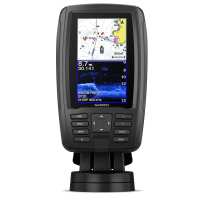
The Plus second generation of the Echomap 45cv features a new large icon based menu system that is even simpler to use then the original. This compact combination unit offers all the funtions that you will need for a small boat or Kaya and it is.easy to install and easy to use. It also features a quick-release mount allowing you to quickly remove your device from power and mount. Bright, sunlight-readable 4.3 inch combo Built-in support for Garmin CHIRP traditional sonar plus CHIRP ClearVü™ scanning sonar (transducer sold separately) Preloaded BlueChart® g3 charts for the United Kingdom, Ireland and Northwest mainland Europe coast Built-in Garmin Quickdraw™ Contours mapping software instantly creates personalized fishing maps on-screen with 1 foot contours as you fish Share waypoints and routes with other ECHOMAP™ or STRIKER™ units Preloaded BlueChart g3 charts Preloaded with highly detailed Garmin BlueChart g3 mapping covering the British Isles in their entirety, including the Thames Estuary, Caledonian Canal, Outer Hebrides, Shetland and Orkney Islands, Isle of Wight, Isle of Man, Lough Neagh, The Shannon river (up to Lough Kee) and the Irish Sea. Continental coverage from Brest, FR to Kiel, DE including the Channel Islands, the Waddenzee, the IJsselmeer, the canals of The Netherlands, the Meuse River to Liege, BE; the Rhine River to Dusseldorf, DE and the Kiel Canal.* CHIRP Sonar The built-in sonar capabilities of ECHOMAP Plus 45cv include CHIRP traditional sonar, one of the most sophisticated sonar technologies available for the fishing and boating public. CHIRP traditional sonar provides amazingly clear target separation and definition, because it puts even more energy onto the target than traditional sonar Clear scanning sonar images Garmin CHIRP ClearVü scanning sonar gives you a nearly photographic image of what’s below your boat. You clearly see structure, submerged objects and fish. Quickdraw Contours to create your own maps Instantly create personalised fishing maps on-screen with 1 foot contours, then tailor them to fit your needs. These are your maps -; you own them. Keep the data to yourself, or share it with the Quickdraw Community on Garmin Connect™. Specifications GPS Antenna: Internal 5Hz Waypoints: 5,000 Routes: 100 Supports AIS (tracks target ships position) Supports DSC (displays position data from DSC-capable VHF radio) NMEA 0183 in/out ports:1 Sonar transmit power: 500 W (RMS) Maximum depth:2,300 ft @ 77 kHz, freshwater 1,100 ft @ 77 kHz, saltwater Bottom lock (shows return from the bottom up) Water temperature log and graph Sonar recording Sonar history rewind Physical dimensions: 4.0" x 8.0" x 3.1" (10.2 x 20.4 x 0.4 cm) Weight:1.6 lbs (0.7 kg) Water rating: IPX7 Display size: 2.1" x 3.7"; 4.3" diagonal (5.4 x 9.5 cm; 10.5 cm diagonal) Display resolution: 480 x 272 pixels Power consumption: 5W Mounting options:Bail or flush In the Box ECHOMAP Plus 45cv with BlueChart g3 for UK, Ireland and Northwest mainland Europe coast Power/data cable 4-pin sounder to 8-pin transducer adapter cable Tilt/swivel mount with quick release cradle Documentation * Preloaded g3 charts do not feature Auto Guidance
Visit Product Page